| FACILITIES INFORMATION SERVICES |
|
| | | |
|
Mapping
All Maps and information on this web site are Copyright © by Vanderbilt University† All Rights Reserved.
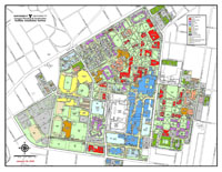
The Facilities Information Services Mapping Department is responsible for the creation and maintenance of the University's campus maps. The utility maps are maintained with a GIS system Arc/Info (ESRI). This information includes communication and fiber optics, electric, natural gas, fuel, chiled water, sewer,steam, water and other mapping considerations.
Requirements for site surveys information shall be referenced to Vanderbilt University control monuments, Tennessee State Plane Coordinates and the North American Datum 83 system.
Individuals needing mapping data may request digital mapping information by completing and submitting the Non-disclosure and Waiver Agreement and/or contacting Mapping 615-343-8394.
|
|
|
Vanderbilt University, 2201 West End Avenue, Nashville, Tennessee 37235
Copyright © by Vanderbilt University† All Rights Reserved.
|
|